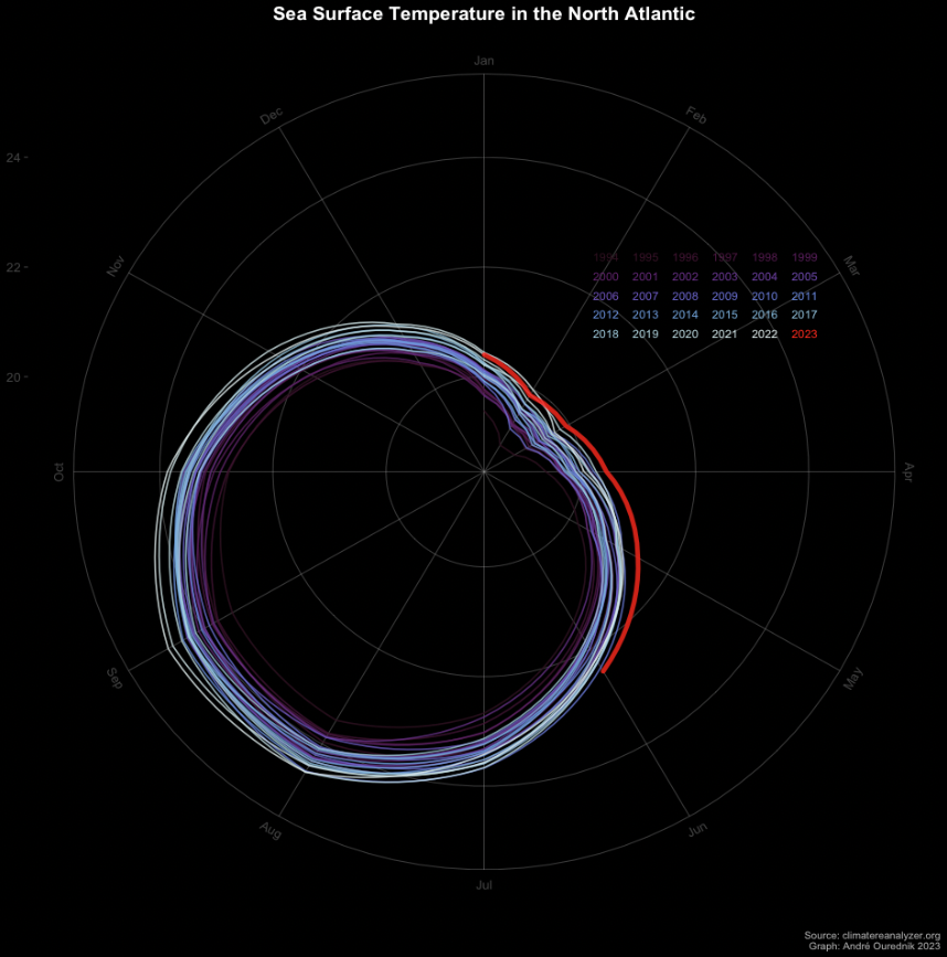
This graphic appeared in social media lot in the last days I wondered how it would render on polar coordinates. So I made an R script to do so. The script is reusable for other data sources as I show below. So reuse, enjoy, and make useful. The plotting function Sea surface tempareature (SST) in […]
Author Archives: André Ourednik
Analyse de séries temporelles avec R
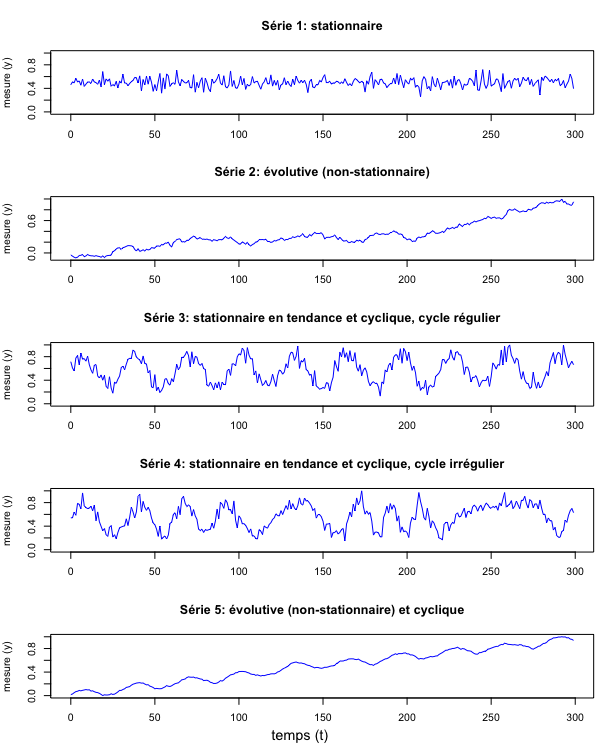
Une “série temporelle” est une suite d’enregistrements d’une variable faits au cours du temps. Cette variable peut être la température, la fréquence d’accidents routiers ou l’amplitude du son enregistré par un microphone. Les mesures peuvent être prises à des intervalles réguliers ou pas. Pour avoir une base de discussion, préparons d’abord quelques données fictives. Ne […]
Figures and Maps of Concepts

This blog entry is work in progress… Please be patient, more content is comming soon. Meanwhile, you can read other posts. Concepts are encoded in most artworks, at least in all that make it to the museum and visiotors bother to see and acedmics to write about. I focus here on major examples. Psyche and […]
Cartographie et géomatique avec R (2024)
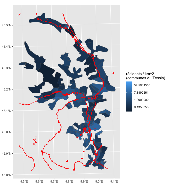
Deux modules R principaux servent aujourd’hui pour le traitement de données géomatiques: Pour comprendre ces modules R en détail, je vous recommande l’excellente documentation de Timothée Giraud & Hugues Pecout. Le présent exercice vise à vous familiariser avec les éléments de base de la cartographie vectorielle avec R. Le prérequis pour comprendre les instructions ci-dessous […]
Railway Track Gauge: a Material Substrate of Nostalgia and Defiance
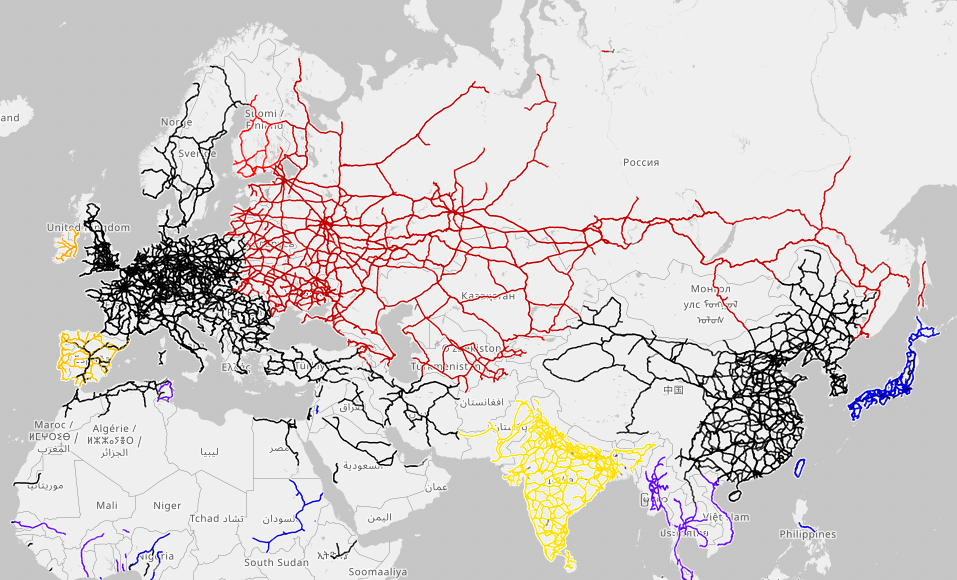
A look at the global map of rail track gauges immediately reminds you of the current invasion of Ukraine. There is a material substrate of the putinist nostalgia of the Muscovite Empire. Far more than a purported linguistic or cultural proximity of the ex-Soviet states, this substrate of steel paves the way for geopolitical ambitions. […]
Imager l’espace vécu – Médiographie
Inspirations (exemples génériques) Livres et articles argumentés Cartographie générale Réseaux (relations, migration, transport, accessibilité) Cartographie en 3D Cartes anamorphiques (cartogrammes) Cartes mentales Voir le blogpost dédié aux cartes mentales. Analyse et visualisation de textes et de relations sématiques Infographie programmatique R et RStudio
The Man from the Future: The Visionary Life of John Von Neumann — a Foreword
I’ve had the pleasure to write a foreword of the French translation of Ananyo Bhattacharya‘s biography of John von Neumann, translated by Anatole Muchnik and now published by Quanto. You can read the French introduction and have a peek at the book’s first chapter (PDF). In agreement with Ananyo, here is the English translation. As […]
Hypertopia: from Utopia to Omniscience
English translation transcript of my conference given in French at the CERN Globe on September 22nd, 2022, and based on the eponymous book from 2019. Tonight, I propose to talk about two ideas, two concepts. The first one you already know: the concept of utopia. The other concept, which I propose to introduce, is the […]
The impossible territory and the maps of the boyar Kraiensky

Figure 1 Overlapping territories of First Nations in the perception of their members. Screenshot from the geomatics site https://native-land.ca/ . Unstable borders are a cartographer’s nightmare. The simple task of reporting on demographic changes quickly becomes a headache in a country whose municipalities merge, divide, and even change their spatial contours according to the projects […]
Écrire l’espace (2022)
Ce cours-atelier introduit à l’espace et à ses figurations comme outil de création et d’expression littéraires Les écrivaines recourent aux cartes de territoires physiques et imaginaires pour poser leur récit. Les fouilleurs de texte (text miners) utilisent des figurations spatiales pour étudier de vastes corpus. Il existe de nombreux types d’espaces: l’espace topographique de la […]