Skip to content
andré ourednik   
info
  • publications
    • fictions
    • scientific
  • évènements
  • maps & spaces
    • Courses
    • Maps
    • Spaces
    • Tools
    • Uncategorized
  • podcast
  • simulations
  • contact
search

Maps and Spaces

Cartes et espaces

Tag Archives: spatial planning

Paths in the green and spatial planning as a translation process

Paths in grass by Alexios Kitsopuloulos

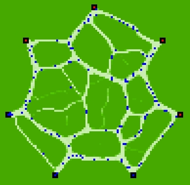
This map is an agent-based simulation result produced by NetLogo. It has been programmed years ago by a friend of mine, Alexios Kitsoupulos, from the University of Lausanne. What you see are paths produced in the green by people moving from one place to another. The basic rules are : – Individuals use existing paths […]

Published: April 25th, 2011 — Updated: May 7th, 2019Posted inMaps, SpacesTags: individual, NetLogo, spatial planning, urbanismLeave a comment on Paths in the green and spatial planning as a translation process
Maps and Spaces, Privacy Policy